What do we mean by "rural"?
Rural-Urban Continuum Codes
The U.S. Department of Agriculture's Economic Research Service (ERS) classifies each of the 3,142 counties in the U.S. into one of nine rurality categories, shown in Table 1. These Rural-Urban Continuum Codes are based on whether a county is located in a metropolitan or non-metropolitan area, using the Office of Management and Budget's 2013 statistical definitions. After differentiating counties by metropolitan/non-metropolitan areas, Rural-Urban Continuum Codes define counties by their population size and proximity to urban areas. We consider "rural" counties to be those with codes of four or higher, representing all non-metropolitan counties in the United States.
Table 1. Rural-Urban Continuum Codes
| Metropolitan | |
|---|---|
| 1 | Counties in metro areas of 1 million population or more |
| 2 | Counties in metro areas of 250,000 to 1 million population |
| 3 | Counties in metro areas of fewer than 250,000 population |
| Non-metropolitan | |
| 4 | Urban population of 20,000 or more, adjacent to a metro area |
| 5 | Urban population of 20,000 or more, not adjacent to a metro area |
| 6 | Urban population of 2,500 to 19,999, adjacent to a metro area |
| 7 | Urban population of 2,500 to 19,999, not adjacent to a metro area |
| 8 | Completely rural or less than 2,500 urban population, adjacent to a metro area |
| 9 | Completely rural or less than 2,500 urban population, not adjacent to a metro area |
Commuting Zones
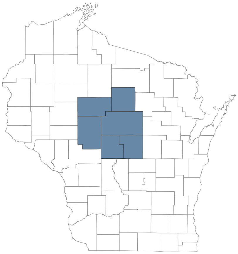
Each of the 3,142 counties in the United States clusters into one of 625 distinct "commuting zones." Recognizing that people often cross county lines to live, work, and commute, the U.S. Department of Agriculture's ERS used U.S. Census Bureau's journey-to-work data to measure the integration of social and economic activity between counties. Figure 1 illustrates how six counties cluster together to form a commuting zone around the area of Wausau, Wisconsin.
Figure 1. Commuting Zone Example (Wausau, Wisconsin)
Rurality of Commuting Zones
To measure the rurality of each commuting zone, we use data from the U.S. Census Bureau's American Community Survey (ACS) and Rural-Urban Continuum Codes from the ERS. With these data, we create a population-weighted measure that first sums the total population of each commuting zone living in rural counties and divides that value by the commuting zone's total population:
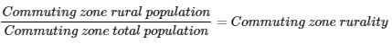
Building on the Wausau, Wisconsin example, Figure 2 shows how this measure captures the rurality of any given commuting zone. Here we can see five of this six-county commuting zone are coded as "rural." Accordingly, we sum the total population of these five rural counties into the numerator and divide by the commuting zone's total population, 361,788, resulting in a commuting zone rurality of 63%.
Figure 2. Calculating Commuting Zone Rurality (Wausau, Wisconsin)
What do we mean by "postsecondary institution"?
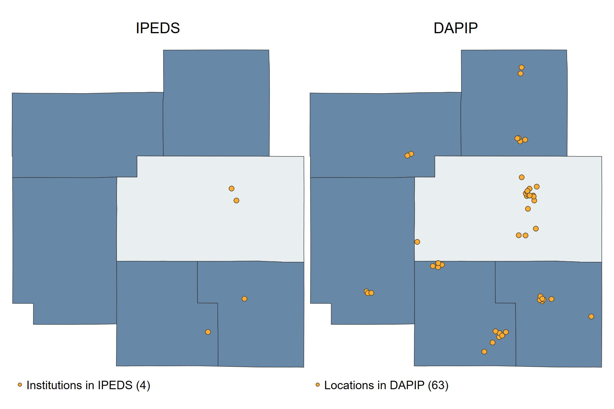
We define postsecondary institutions using IPEDS data merged with data from the U.S. Department of Education's Database on Accredited Postsecondary Institutions and Programs (DAPIP). DAPIP provides the street address of accredited parent and child institutions and includes "additional locations." These "additional locations" provide a wider and more complete list of where college opportunities are located: the cleaned DAPIP dataset includes 24,455 total locations while IPEDS includes roughly 7,000. Figure 3 illustrates the benefit of merging IPEDS with DAPIP, where the left panel shows the IPEDS "parent" and "child" locations of Wausau, Wisconsin's commuting zone and the right adds all additional locations from DAPIP. According to IPEDS, there are only four colleges located in this commuting zone while DAPIP counts 63 locations that include various types of offerings outlined in more detail below.
Figure 3. Locations in IPEDS compared to DAPIP
Classifying DAPIP location types
Our research team analyzed this novel dataset in three distinct ways. First, we geocoded each DAPIP location based on its street address and then merged those locations with their respective commuting zone. Second, we ran a word-frequency query (using NVivo software) on each location's name. Third, we used text-based algorithms and manual coding to apply those thematic word clusters to each DAPIP location, resulting in the following list of location types:
Table 2. DAPIP Location Types
| Main Campus Locations | |
|---|---|
| 1 | Institution |
| 2 | Branch Campus |
| Additional Locations | |
| 3 | K-12 Education Setting |
| 4 | Hospital/Medical |
| 5 | Private Companies and Hotels |
| 6 | Corrections |
| 7 | Inter-Institutional Program |
| 8 | Military Bases/Military Academies |
| 9 | Administrative and Extension Offices |
| 10 | Miscellaneous Community Agencies |
DAPIP reports three types of locations for each observation in its dataset: institution; additional location; and site. An "institution" is a main campus which serves as the primary contact for accrediting agencies. Unlike the unique identification number colleges use in IPEDS (e.g. "UNITID") to signify the holder of the PPA, the DAPIP file includes locations where instruction occurs. An "additional location" is defined as "a facility that is geographically apart from the main campus of the institution and at which the institution offers at least 50 percent of a program and may qualify as a branch campus." These would only appear in IPEDS if the location held its own PPA, which is often unlikely, meaning we are able to identify many more "additional locations" where instruction occurs. Finally, DAPIP's data documentation lists a "site" as "a location used for the supervised practical training of advanced students or recent graduates in areas such as medicine, psychology, and dietetics. Or location used for the specialized clinical training of physicians." Because locations deemed "sites" serve a very specific purpose for training of advanced degrees, we excluded them from this tool.
In the DAPIP dataset, just over 16,000 observations are coded as "additional locations." By applying the text-mining techniques, we generated eight sub-groups of "additional locations" using key words. The following table demonstrates the words and phrases that were used to code the categories. In some instances, we included typos reported to the accreditors within our code (e.g., "Dsitrict" or "Schoo") to capture frequently mistyped occasions of words. Code for this process only included observations that DAPIP classified as "additional locations."
Table 3. Keywords Used in DAPIP Coding
Code for all pulled in lower- and upper-case instances of words or phrases; words separated by semicolon.
| Category | Words/Phrases |
|---|---|
| Branch Campus | Campus; Community; College; Business College; Marinello School of Beauty; I.T.S.; Empire Beauty; Regency Beauty; G Skin; The Studio Academy of Beauty; Jones Beauty; Drexel University at; Western International University at Maricopa County; County Career; Ocean County Vocational; State College at; Colorado State University at; Colorado State University -; School of; Adams State University |
| K-12 Education Locations | Public School; School District; School Dsitrict; Elementary; Elementary School; Middle School; H[iI]gh School; Charter School; International School; Montessori School; Intermediate; Montessori; Department of Education; HS; H.S.; High Schoo; Board of Education; School Distict; Elementary Sch; Elem School; Test Prep; Youth Center; Neighborhood Center; Catholic School; Secondary School; Local School; City School; Junior High; ISD; Primary School; Unified District |
| Hospital/Medical Locations | Hospital; Hospital ; Medicine; Medical Center; Health Care; Health System; Healthcare; Residency; Clinic; VAMC; Internship; Care System; Health Service; Premier Health; Franciscan Health; Baptist Health; Mayo Clinic; Health Center; Predoctoral Internship |
| Private Companies and Hotels | Hotel; Inn ; Inn; Conference Center; Suites; AmericInn; Best Western; Lodge; Marriott; Hilton; Sheraton; Hyatt; Hotel; Hampton Inn; Hampton Suite; Ritz Carlton; Lockheed; Boeing; Verizon; Dale Carnegie; Raytheon; Business Incubator; Equipment Operations; Corporation; Mart; Walmart; Mc[dD]onald; Tyson Foods; Bosch Power; United Airline; Credit Union; Kohls; Corporate Center; Super Center; Business Center; Maintenance; Corp; Casino; Pfizer; Verso; Anthem Blue; Airport; Staples; Company; Hyundai; Golf Course; Incorporated; CenturyLink; Assembly Plant; Nuclear Power Plant; Nuclear Plant; General Electric; Allstate; Farm; American Family; Cisco System; Bank |
| Corrections | Correctional; Prison; Penitentiary; Jail; Correction; Probation; Detention |
| Military Bases | Base; Joint; Military; Force; Naval; Arsenal; Coast Guard; Marine Corps; Barracks; Infantry; US Navy; U.S. Navy; US Army; U.S. Army; USCG; Camp Smith; Pearl Harbor; Warfare; Combat; Air National Guard; National Guard; AFB |
| Administrative and Extension Offices | Administration; Administrative; County office; Extension |
| Miscellaneous Community Agencies | Fire Department; Fire District; Fire Station; Police Department; Ctr; FD ; Child and Adolescent Services Center; Language Center; Rec Center; Recreation Center; Community Center; Counseling Center; Regional Center; Aquatic Center; Innovation Center; Civic Center; City Hall; Rescue Center; Development Center; Treatment Center; Wellness Center; Community Services; Department of Public Health; Department of Health Services; Library; Police Dep; Police Officers; Courthouse; Court House; Retirement Community; Club; Rifle; Children's Services; County Sherriff; Maricopa County; County Department; County Health; Riverside County Adult; County Fire; County Adult; County Lifelong; Chamber of Commerce; Village Hall; Circuit Court; University Center of Lake County |
DAPIP is an unaudited dataset which means there are likely to be inconsistencies in how data are reported. While our line-by-line review resolved many of these issues (e.g., typos in names or locations) the dataset is not without limitations. Additionally, our procedures for flagging each additional location – and the 8 types of "additional location" we identified – should be understood as a first attempt at classifying these places that to our knowledge have been underexplored and unevenly documented in the research literature. Ultimately, we conducted multiple rounds of quality control, both manually and with text-based algorithms, resulting in 24,455 observations for this analysis.